Satellite Depth Map
Click the map to enlarge. The deepest basins — around 24 m (80 ft) — sit in the wide central and eastern bays, while the long arms and channels stay shallow. The two township boat launches are marked: the main one off Crotch Lake Access Road and the rougher north launch off South Bush Road.
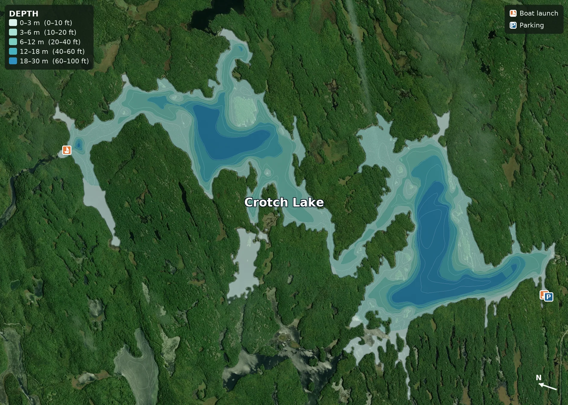
Depth shown in metres and feet (see on-map legend). Bathymetry: Ontario MNRF (Bathymetry, Line). Shoreline: OpenStreetMap. Satellite: Esri World Imagery.
About Crotch Lake
Crotch Lake sits in the Township of North Frontenac, in the rugged lake country of the Frontenac Highlands about a 1.5-hour drive northwest of Ottawa. It's the largest and most accessible lake in the North Frontenac Parklands program — roughly 5,300 acres (2,145 ha), about 14 km long, with more than 90 km of undeveloped wilderness shoreline wrapping around rocky points, sheltered bays and dozens of islands.
It's one of eastern Ontario's premier inland walleye lakes, and it also holds smallmouth and largemouth bass, northern pike, yellow perch, black crappie, rock bass, sunfish and bullhead. The sheer size of the lake spreads anglers out, and most of the shoreline is Crown land — large peninsulas on the east and west form the Crotch Lake Conservation Reserve, set aside under Ontario's 1999 Living Legacy program.
Almost everything here is boat-access: of the 72 maintained campsites, only four are drive-in and the rest are scattered around the lake, reached by canoe, kayak or boat. Two township-maintained boat launches sit at opposite ends of the lake — but note that a Road Access Permit is required to drive the Crown roads in to them (see below).
- RegionFrontenac Highlands (FMZ 18)
- TownshipNorth Frontenac, ON
- From Ottawa~1.5 h drive
- Size~5,300 ac · ~14 km long
- Shoreline90+ km, mostly undeveloped
- Max depth~24 m (80 ft)
- Boat launchesSouth (Crotch Lake Access Rd) & north (South Bush Rd)
- Camping72 backcountry sites (4 drive-in)
- Fish speciesWalleye, bass, pike, perch, crappie
Fishing Regulations
Ontario Fisheries Management Zone 18 · Source: Ontario Fishing Regulations Summary — FMZ 18. Seasons and limits change — always confirm the current FMZ 18 rules before you fish.
⚠️ Spring sanctuary on Crotch Lake. The FMZ 18 summary lists a fish sanctuary on Crotch Lake and the Mississippi River (Palmerston Township), from Sidedam Rapids to the north shore of Skull Island, including McLean's Bay — closed to fishing from March 1 to the Friday before the second Saturday in May to protect spawning fish. Check the current summary for the exact boundary and dates before fishing those waters in spring.
| Species | Open Season (FMZ 18) | Sport Limit | Conservation Limit | Notes |
|---|---|---|---|---|
| Walleye & Sauger | Jan 1 – Mar 1 & 2nd Sat. May – Dec 31 | 4 | 2 | Size limit: kept fish must be between 40–50 cm (per the FMZ 18 summary). Spring sanctuary applies — see above. |
| Smallmouth & Largemouth Bass | 3rd Sat. June – Dec 15 | 6 | 2 | Combined limit for both species. |
| Northern Pike | Jan 1 – Mar 31 & 2nd Sat. May – Dec 31 | 6 | 2 | |
| Yellow Perch | Open all year | 50 | 25 | |
| Black Crappie | Open all year | 30 | 10 |
Limits are daily catch & possession. Sport = Sport fishing licence. Conservation = Conservation licence. · Bait rule: FMZ 18 is in the Southern Bait Management Zone — live or dead baitfish and leeches cannot be transported into or out of the zone. Only preserved (dead) bait may cross zone boundaries. Confirm all seasons, limits and size rules in the current FMZ 18 summary before keeping fish.
Camping & Dark Skies
Backcountry campsites, the Road Access Permit, and some of the darkest skies in southern Ontario.
Crotch Lake is the flagship lake of the North Frontenac Parklands, with 72 maintained backcountry campsites. Only four are drive-in; the rest are scattered around the shoreline and islands and are reached by canoe, kayak or boat. Sites are reserved through the Township of North Frontenac, and the unspoiled pine forest, rocky points and clear blue water make it a classic eastern-Ontario backcountry trip.
A Road Access Permit is required from April 1 to November 15 for any use of the roughly 33 km of Crown roads in the North Frontenac Parklands, including the roads in to both boat launches. One complimentary permit comes with each campsite reservation; extra vehicles need their own. Fees are reinvested by the Township in maintaining the roads, launches and campsites.
Crotch Lake also sits inside the North Frontenac Dark Sky Preserve — in 2013, North Frontenac became the first municipality in Canada certified as a Dark Sky Preserve by the Royal Astronomical Society of Canada. With almost no light pollution and a shoreline of secluded sites, it's one of the best places in southern Ontario to camp under the Milky Way. The Township also runs the North Frontenac Astronomy Park near Plevna for public stargazing.
Plan your trip and reserve sites through the North Frontenac Parklands — Crotch Lake page, and pack out everything you pack in to keep the lake wild.
Crotch Lake on Video
See the lake, the campsites and the fishing before you make the drive.
Trip Tips
🎣 Find the walleye
Work the rocky points, islands and shoals where the bottom drops into the deeper central and eastern basins. Early and late in the day are prime; bring electronics to find the structure and the schools.
🪪 Get a Road Access Permit
From April 1 to November 15 you need a North Frontenac Parklands Road Access Permit to drive the Crown roads in to the launches. One comes with a campsite booking; otherwise buy one before you go.
🚤 Pick the right launch
The main, most accessible launch is at the south end off Ardoch Road (Crotch Lake Access Road), with parking above the ramp. The north launch off South Bush Road near Ompah is rougher — best with a 4×4.
🌌 Stay for the stars
Crotch Lake is inside the North Frontenac Dark Sky Preserve. On a clear, moonless night the Milky Way is stunning from a quiet boat-access campsite — bring a red flashlight and let your eyes adjust.
Getting There
From Ottawa, take Highway 7 west toward Sharbot Lake, then Road 509 north toward Ardoch and Ompah. For the main south launch, turn onto Ardoch Road and follow Crotch Lake Access Road to its end at the lake (≈ 44.868, −76.809); parking is above the ramp. The north launch is reached from Road 509 near Ompah via South Bush Road to the water — that road is rougher and best driven with a 4×4. Remember a Road Access Permit is required on the Crown roads in (April 1 – November 15).