Satellite Depth Map
Click the map to enlarge. Mazinaw is two basins joined by The Narrows: the larger, deeper North (Upper) Mazinaw holds the great trench that plunges past 130 m (430 ft) at the base of Mazinaw Rock, while the South (Lower) Mazinaw basin runs shallower. The public Tappings Landing boat launch and its parking are marked on the west shore.
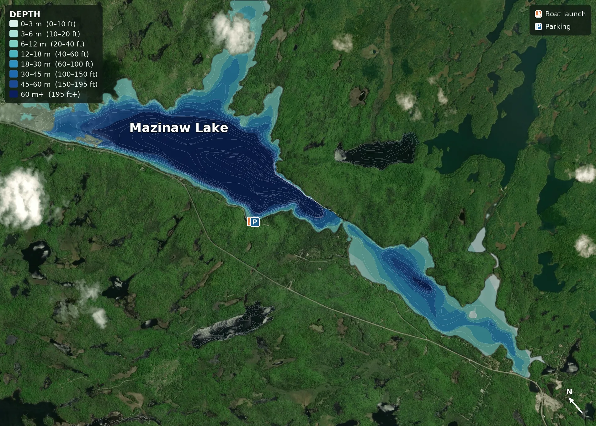
Depth shown in metres and feet (see on-map legend). Bathymetry: Ontario MNRF (Bathymetry, Line). Shoreline: OpenStreetMap. Satellite: Esri World Imagery. Bathymetry contours shown reach ~134 m; the lake's surveyed maximum is ~145 m (476 ft).
About Mazinaw Lake
Mazinaw Lake sits in the Addington Highlands, on the southern edge of the Canadian Shield north of Kaladar, about a 2.5-hour drive from Ottawa. The name comes from an Algonquin word meaning "picture" or "writing" — for the painted rock that towers over its eastern shore. A narrows splits the lake into two basins: North (Upper) Mazinaw, the larger and deeper, and South (Lower) Mazinaw.
It is one of Ontario's deepest lakes — average depth about 41 m and a maximum of roughly 145 m (476 ft), the seventh-deepest in the province (Great Lakes included). That depth, plus the clear, low-nutrient water, makes Mazinaw a true cold-water fishery: native lake trout hold in the deep, oxygen-rich basins, with smallmouth and largemouth bass, walleye, northern pike, yellow perch, lake whitefish, burbot and sunfish through the rest of the lake.
Most of the eastern shore — including the cliff itself — lies inside Bon Echo Provincial Park. Anglers trailering a boat use the public Tappings Landing launch on the west shore; the park itself is a canoe-and-kayak operation (see below).
- RegionAddington Highlands (FMZ 18)
- CountyLennox & Addington, ON
- From Ottawa~2.5 h drive
- Length~21 km · 49 km shoreline
- Max depth~145 m (476 ft)
- Avg depth~41 m (135 ft)
- Boat launchTappings Landing (public, west shore)
- ParkBon Echo Provincial Park
- Fish speciesLake trout, smallmouth, walleye, pike, perch, whitefish
Fishing Regulations
Ontario Fisheries Management Zone 18 · Source: Ontario Fishing Regulations Summary — FMZ 18. Seasons and limits change — always confirm the current FMZ 18 rules before you fish.
❄️ Lake trout is a summer-only fishery here. In FMZ 18 the lake trout season runs the fourth Saturday in May to September 8 — there is no winter (ice) lake-trout season. Walleye and pike do have a winter season, so Mazinaw can be fished through the ice for those. No FMZ 18 species exception or fish sanctuary is listed specifically for Mazinaw Lake, but check the current summary before you go.
| Species | Open Season (FMZ 18) | Sport Limit | Conservation Limit | Notes |
|---|---|---|---|---|
| Lake Trout | 4th Sat. May – Sept 8 | 2 | 1 | Summer season only (no winter fishery). Counts toward the aggregate trout/salmon limit (S-5 / C-2). |
| Walleye & Sauger | Jan 1 – Mar 1 & 2nd Sat. May – Dec 31 | 4 | 2 | Kept fish must be between 40–50 cm (per the FMZ 18 summary). |
| Smallmouth & Largemouth Bass | 3rd Sat. June – Dec 15 | 6 | 2 | Combined limit for both species. |
| Northern Pike | Jan 1 – Mar 31 & 2nd Sat. May – Dec 31 | 6 | 2 | |
| Lake Whitefish | Open all year | 12 | 6 | |
| Yellow Perch | Open all year | 50 | 25 |
Limits are daily catch & possession. Sport = Sport fishing licence. Conservation = Conservation licence. · Bait rule: FMZ 18 is in the Southern Bait Management Zone — live or dead baitfish and leeches cannot be transported into or out of the zone. Only preserved (dead) bait may cross zone boundaries. Confirm all seasons, limits and size rules in the current FMZ 18 summary before keeping fish.
Bon Echo & Mazinaw Rock
A 100-metre painted cliff, 260+ Indigenous pictographs, and one of Ontario's classic provincial parks.
The eastern shore is dominated by Mazinaw Rock — a sheer granite cliff that rises about 100 m (328 ft) straight out of the lake and runs roughly 1.5 km along the water. Its face carries more than 260 Indigenous pictographs painted in red ochre by Algonquin (Anishinaabe) ancestors hundreds of years ago — the largest visible collection of rock art on the southern Canadian Shield and the only major pictograph site in southern Ontario. Mazinaw Lake and Mazinaw Rock were declared a National Historic Site of Canada in 1982. This is a sacred place; visitors are asked never to touch the paintings.
Near water level is "Old Walt" — a giant inscription of a Walt Whitman verse carved into the rock in 1919, a tribute placed by the park's early steward Flora MacDonald Denison. The pictographs and the inscription can only be seen from the water: paddle along the base by canoe, or take the park's interpretive Wanderer boat tour. The signature Cliff Top Trail climbs the rock for sweeping views of the lake, but it is reached only by canoe or the seasonal ferry across the narrows.
Bon Echo Provincial Park protects over 8,000 ha around the lake, with a large campground, beaches, canoe and kayak rentals, and miles of paddling. Note that the park is a paddling park — there is no motorboat ramp inside it, so anglers bringing a powerboat launch at the public Tappings Landing ramp on the lake's west shore. Plan and reserve through Ontario Parks — Bon Echo.
Mazinaw Lake on Video
See the lake, the rock and the fishing before you make the drive.
Trip Tips
🎣 Go deep for lake trout
Through summer the trout sit deep in the cold, oxygen-rich North basin. Troll spoons or worm harnesses down along the 15–30 m breaklines, or jig the deep flats. Early season they cruise shallower right after ice-out.
🪨 Fish the rock
The shoal off the north end of Mazinaw Rock is a known smallmouth spot. Work drop-shots and Ned rigs on the rocky/weedy flats in 5–10 ft, and try topwater over the weed tops on a calm evening.
🚤 Launch at Tappings Landing
Bon Echo Provincial Park has no motorboat ramp. Trailer in to the public Tappings Landing launch on the west shore (≈ 44.912, −77.208), where there's parking above the ramp.
🛶 See the pictographs
The 260+ pictographs and the "Old Walt" inscription are only visible from the water. Rent a canoe or take the park's Wanderer boat tour to see them up close — and never touch the painted rock.
Getting There
From Ottawa, take Highway 7 west to Kaladar, then Highway 41 north toward Cloyne. Bon Echo Provincial Park's main gate is on Highway 41 on the lake's south side. For the public boat launch, continue to the Tappings Landing ramp on the west shore of the North basin (≈ 44.912, −77.208); parking is above the ramp. From Toronto it's about a 3-hour drive via Highways 401 and 41.